The heartland of the U.S. was once again drenched by relentless rains along a nearly stationary front, according to this week’s drought summary from the National Drought Mitigation Center.
Last week, heavy rain again fell on parts of the Nation’s Midsection along a strong quasi-stationary front. A swath of heavy amounts (over 2 inches) extended from central Texas northeastward through eastern Oklahoma, southeastern Kansas, northwestern Arkansas, much of Missouri, and southern Illinois. The largest amounts (4 to locally 8 inches) covered a band from the Middle Red River (south) Valley into central Missouri.
Farther north, 2 to 4 inches also soaked much of southeastern Nebraska, eastern Iowa, and central through southwestern Wisconsin. More widely scattered amounts of 2 to 4 inches affected southeastern Texas, northern Louisiana, and the northern half of Alabama.
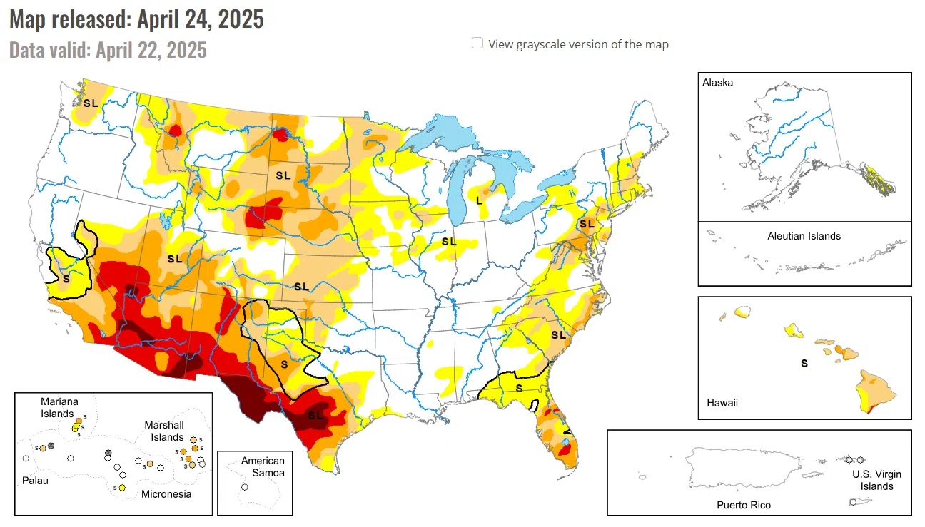
Meanwhile, subnormal amounts propelled intensifying drought and dryness along parts of the East Coast, scattered portions of the Southeast. East-central and southern Texas, parts of the central and northern Plains, and both the northern and southern tiers of the Rockies and adjacent lower elevations.
High Plains
Moderate to locally heavy precipitation (over 0.5 inch, with isolated amounts topping 2 inches) fell on some of the higher elevations of Colorado and Wyoming. On the other side of the Region, heavy rains, amounting to several inches in some places, doused southeastern Kansas. Elsewhere, amounts exceeded 0.5 inch in several scattered areas mostly in the High Plains and central Kansas, but most other locales recorded a few tenths at best.
Dryness and drought broadly improved by one category across a broad section of southeastern Kansas, and more localized improvement was noted in some of the wetter areas of the higher elevations. Conditions were mostly unchanged across the rest of the High Plains, but a few localized areas worsened enough to increase one category on the map.
Extreme drought (D3) continued to affect much of southeastern Colorado and portions of adjacent southwestern South Dakota and western Nebraska. Less than half of normal rainfall was reported over the past 90 days in some areas of west-central and north-central South Dakota, northeastern and southeastern Nebraska, and central through southern Kansas.
Midwest
Conditions varied considerably across this Region, as has been the case for the past several weeks. Moderate to heavy rain (generally over 1.5 inches) fell on a sizeable area covering most of Missouri, southern Illinois, central and eastern Iowa, southeastern Minnesota, and central through southwestern Wisconsin. The heaviest amounts (4 to 8 inches) were fairly widespread across central and southwestern Missouri. Any dryness or drought in most of these areas improved notably with the exception of a portion of interior northeastern Iowa, where 60- and 90-day amounts remained below normal.
Moderate to locally heavy precipitation (generally 0.5 to 2.0 inches) fell across the rest of the central and northern Great Lakes Region, central Illinois, and part of southwestern Indiana. Elsewhere, most locations reported a few tenths of an inch. Kentucky was generally dry, but intense rains during the prior few weeks kept any dryness at bay there, and this week’s deluging rainfall in Missouri removed most of the large abnormally dry (D0) area that had covered most central, northern, and western parts of the state.
The rainfall across Wisconsin and Michigan eroded dryness and drought in those states, though some moderate to severe drought (D1-D2) stubbornly persisted in the east-central Lower Peninsula. Drought coverage (D1) increased in northern Minnesota, which was missed by the heavier precipitation. In the far northwestern part of the state, areas near the Canadian border have received only about half of normal precipitation for the past 1-2 months.
National Drought Mitigation Center
University of Nebraska-Lincoln


Comments