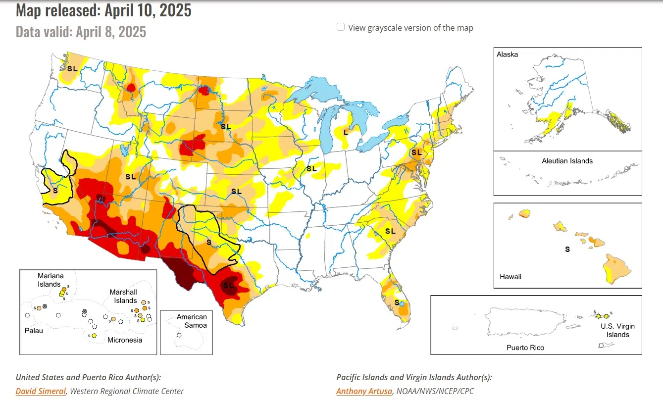
In the Midwest, this week’s rainfall event pushed rainfall totals well above normal levels for the past 30-day period, leading to improvements across the Midwest in Missouri, Illinois, Indiana, and Michigan. In the Upper Midwest and portions of the Plains, drought-related conditions improved on the map across areas of Minnesota, Wisconsin, and South Dakota, where precipitation has been above normal for the past 30-90-day period and soil moisture monitoring products are showing normal to above-normal levels.
Midwest
Widespread improvements were made across the Midwest region in response to this week’s severe storm event that delivered very heavy rainfall accumulations and severe flooding to parts of the region including Missouri, Kentucky, Illinois, Indiana, Michigan, and Ohio. The multi-day storm caused widespread power outages, catastrophic flooding, damaging winds, and tornadic outbreaks. Precipitation totals for the storms ranged from 2 to 18+ inches, with the highest totals logged in western Kentucky. The rainfall improved conditions on the map in Missouri, Illinois, Indiana, Ohio, and southern Michigan. Elsewhere in the region, above-normal precipitation during the past 30-90 days, led to reductions in areas of drought in Minnesota, Wisconsin, and northern Michigan. For the week, average temperatures were below normal across most of the region, with anomalies ranging from 2 to 8 degrees F above normal.
High Plains
On this week’s map, improvements were made in the region, namely in northern Kansas, northern Nebraska, and South Dakota, where shorter-term precipitation (past 30-60 days) is normal to above normal. Additionally, these areas were showing improvements in other drought indicators including soil moisture, streamflow activity, and satellite-based vegetation health. In western North Dakota, areas of Extreme (D3), Severe (D2), and Moderate (D1) drought expanded on the map in response to a combination of factors, including numerous recent impact reports from the agricultural sector, below-normal precipitation (past 30 days), and low streamflow and soil moisture levels. For the week, generally dry conditions prevailed across western portions of the region, while eastern portions received modest accumulations of <1.5 inches (liquid). In terms of temperatures, below-normal average temperatures (ranging from 2 to 10+ degrees F) were logged across the entire region.
Looking Ahead
The NWS Weather Prediction Center (WPC) 7-Day Quantitative Precipitation Forecast (QPF) calls for relatively dry conditions across the conterminous U.S., except for light-to-moderate accumulations across areas of the Pacific Northwest, northern Plains, Lower Midwest, Mid-Atlantic, and the Northeast. The Climate Prediction Center (CPC) 6-10-day Outlook calls for a moderate-to-high probability of above-normal temperatures across the Western U.S., Plains, and areas of the South, while below-normal temperatures are expected across eastern portions of the Midwest and portions of the Northeast. Elsewhere, near-normal temperatures are favored. In terms of precipitation, there is a low-to-moderate probability of above-normal precipitation across New Mexico, Texas, and Oklahoma as well as areas of the Upper Midwest. Elsewhere, below-normal precipitation is expected across most of the West, Southeast, and Mid-Atlantic.
You can view the full report here.
National Drought Mitigation Center
University of Nebraska-Lincoln


Comments