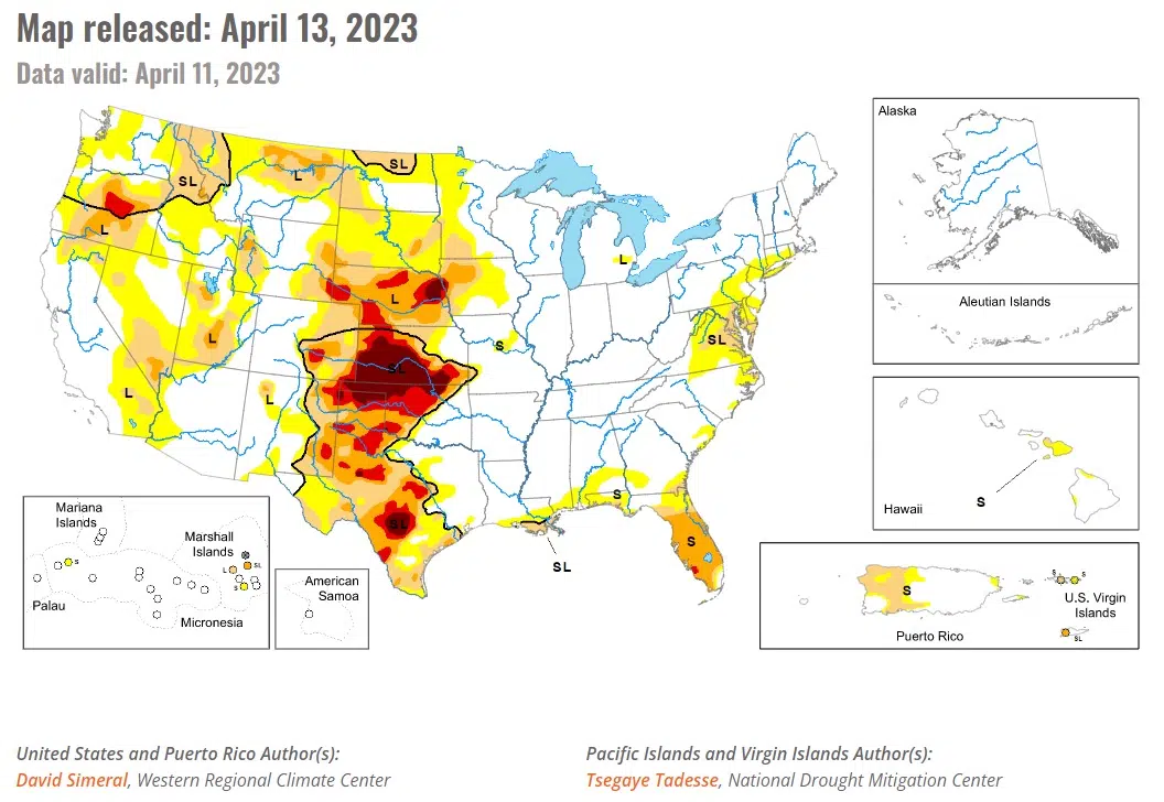
The U.S. Drought Monitor this week saw continued improvements on the map across areas of the West including California, Nevada, Idaho, Montana, and Utah. In the Plains states, drought-related conditions degraded in the southern Plains in Kansas and Oklahoma. In Kansas, the past 9-month period (July 2022-March 2023) has been the 4th driest on record, according to the NOAA National Centers for Environmental Information. In the northern Plains, the conditions on the map improved in response to recent significant winter storm events that helped to boost snowpack conditions in North Dakota where numerous weather stations broke all-time snow depth records for April, according to the North Dakota State Climate Office.
In the Dakotas, deep snowpack conditions were observed this month as well as recent rapid melting which has boosted soil moisture levels significantly (leading to improvement on the map) as well as concerns over major flooding. Flood warnings have been issued for numerous rivers across the Dakotas.
According to NOAA, North Dakota logged its 32nd wettest March on record while Nebraska observed its 28th driest and Kansas its 14th driest. In terms of average temperatures, North Dakota observed its 5th coldest March and South Dakota its 16th coldest on record, For the 12-month period (April 2022-March 2023), Nebraska experienced its 11th driest on record while Kansas its 17th driest.
In the Midwest region, average temperatures for the week were above normal (1 to 6 degrees F) across most of the area except for areas of Minnesota and northern Wisconsin where temperatures ranged from 2 to 12 degrees F below normal. According to NOAA NCEI, average temperatures were near normal across much of the region during March 2023. However, cooler-than-normal temperatures were observed in Minnesota (30th coldest, -4.0 degrees F anomaly) while Michigan was above normal (42nd warmest, +2.5 degrees F anomaly).
Authors: David Simeral, Western Regional Climate Center
Tsegaye Tadesse, National Drought Mitigation Center


Comments